GPS Fix Data
Moving Map Menu / Show GPS Fix Data
This information is read from the NMEA sentences output by the GPS.
Notes
-
To display this information, your GPS must be connected and must output
the GSV NMEA sentences.
- Garmin PVT mode cannot be used because it does
not output any Satellite fix information. It outputs position, speed, course
and altitude which can already be read from OziExplorers standard dialogs.
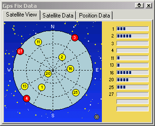
Satellite View - a graphical display shows the satellites
your GPS has connected with.

Satellite
information
- each satellite is identified by its PRN number
- yellow satellite - fix OK
- red satellite - no fix
The small light in the bottom right corner of the Satellite View display
will flash when NMEA sentences are being received.
The bar graph shows the signal level (SNR) of the satellites in view. The
signal level scale is between 25 (min) and 70 (max).
Satellite Data

- Fix Quality
- Number of Satellites the GPS is tracking
- Horizontal Dilution of Precision
- Time in secs since the last DGPS update
- DGPS Station number being used
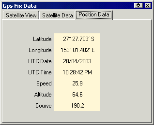
Position Data - of the current position from the NMEA sentences.

The data is presented in the same units that are used in the NMEA sentences.
- Latitude and Longitude in the format selected for main window display
and uses the datum the GPS uses for sending the data.
- Date is in UTC
- Time is in UTC
- Speed is in knots
- Altitude is in metres
- Course is in degrees True


